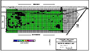
using
Surfer for Windows software; smoothing and contrasting color contouring
schemes are selected as needed. Contour maps are labeled with objects of known
interference (fences, sewer lines, etc) and interpreted features using information
from field notes and suspected conditions.
Contour map of magnetic anomalies of a
landfill.
Similar
to EM data, magnetic data are often computer gridded, producing a data set which
can be contoured or displayed as a 3-dimensional surface.
Full data processing and editing are applied to the data once out of the field
and back in the office. The various steps applied during processing are data-specific
but include conversion of data from a raw file format to a standard (X, Y, Z)
file format. Data are gridded

email:
consultants@geosphereinc.com
124 north auburn road auburn, mi 48611 tel: (989) 662-6149
fax: (989) 662-7701
copyright ©1990-2007 geosphere inc