Purpose:
Proposed landfill construction at the site required knowledge of the bedrock
surface topography. A seismic refraction survey was performed to map
the bedrock surface.
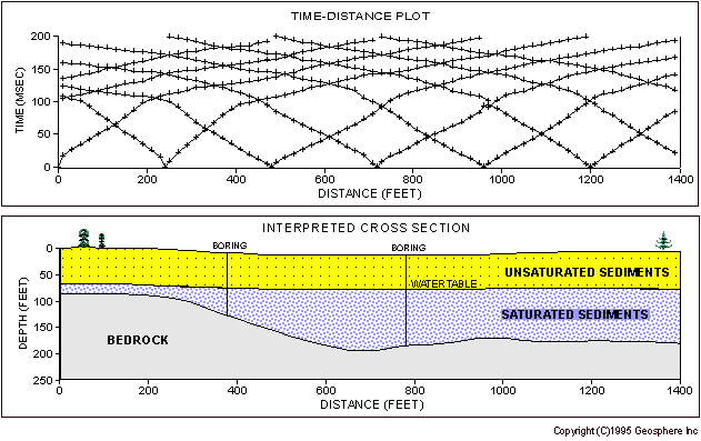
Results: The interpreted bedrock depths
closely matched existing boring information in the area. The survey
was able to provide bedrock depths along the entire traverse, filling in information
between and beyond the borings.
Discussion: A seismic refraction investigation
is performed by measuring the time it takes a seismic pulse to travel from
the shot point location to geophones spaced out along the traverse.
These arrival times are plotted against shot-geophone distance as shown in
the upper figure. This information is used to calculate the thickness
and seismic velocity of each layer present beneath the traverse. The
seismic velocities are used to interpret the nature of each layer. The
lower figure is the interpretation of the data shown in the upper figure.
The borings shown in the figure stopped at the bedrock surface.
![]()
email:
consultants@geosphereinc.com
124 north auburn road auburn, mi 48611 tel: (989) 662-6149
fax: (989) 662-7701
copyright ©1990-2007 geosphere inc