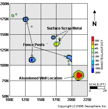
detector commonly used to locate steel survey pins marking property corners. Several pieces of scrap metal were found by this method, but the well was not found. After arriving on site, Geosphere collected magnetometer data over a grid established over the probable location of the well. Additional data were collected on a smaller grid centered over an isolated anomaly detected outside the original grid. Systematic data collection over the grid system eliminated holes in the coverage. Data were digitally acquired and processed to yield a color contour map on site; the map was used to prioritize the strongest anomalies that might be associated with the iron well casing. Excavation following the survey quickly uncovered the well at the strongest magnetic anomaly identified in the accompanying map at a depth of approximately 5 feet.
![]()
email:
consultants@geosphereinc.com
124 north auburn road auburn, mi 48611 tel: (989) 662-6149
fax: (989) 662-7701
copyright ©1990-2007 geosphere inc