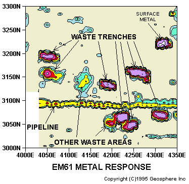
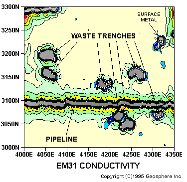
the EM31 and EM61. This density of coverage permitted the recognition of underground utilities and culverts which often disrupt the interpretation of studies with lower density coverage.  Note in the figure above that the water pipeline produced an EM31 anomaly 50 feet wide, but nearby waste trenches are still identifiable.  The EM61 results provide even higher resolution and minimize the "width" of the pipeline.  Both methods were used at this site because the EM31 is capable of responding to deeper targets and "filters" out small scattered metal.  As seen above, both methods detected burial trenches.  In addition, the EM61 detected many smaller objects surrounding the major burial zones, indicating that the trenches were emplaced in larger landfilled areas.

email: consultants@geosphereinc.com
124 north auburn road auburn, mi 48611 
tel: (989) 662-6149  fax: (989) 662-7701
copyright ©1990-2007 geosphere inc

Purpose: Historical aerial photographs and old records indicated the presence of buried waste materials scattered over an area of 30 acres.  In planning the excavation of these industrial wastes, knowledge of their exact extent and distribution was required.  EM conductivity and metal detector surveys were performed with EM31 and EM61 instruments to delineate suspected burial trenches, pits, tanks, and scattered cylinders.

Results: Many burial features were accurately mapped by the investigation.  These trenches and pits contained large concentrations of metal such as drums and industrial debris.  Several features were found that were not identified by early reconnaissance work.

Discussion: Excavation and removal of buried wastes could not be planned or executed without better definition of waste
limits than provided by historical photographs.  A high density coverage of the site was undertaken with 10 foot line spacings and data collected at 2.5 and 1 foot intervals for
2. MAPPING WASTE PITS
Case Studies