Downhole Methods

Introduction
 Comprehensive borehole
evaluation is one of the most important aspects of almost every subsurface geological
evaluation. Drill cuttings are rarely enough to provide all the information necessary.
Even split-spoon and other detailed sampling methods often fail to properly evaluate
the geology and geochemistry around a borehole. Geosphere offers a suite of downhole
wireline tools which can fill this information gap.
Comprehensive borehole
evaluation is one of the most important aspects of almost every subsurface geological
evaluation. Drill cuttings are rarely enough to provide all the information necessary.
Even split-spoon and other detailed sampling methods often fail to properly evaluate
the geology and geochemistry around a borehole. Geosphere offers a suite of downhole
wireline tools which can fill this information gap.
 Downhole methods at Geosphere can be separated into two basic categories: borehole
video and geophysical logging. Both systems are housed
in a climate-controlled van for easy mobilization to distant sites.
Downhole methods at Geosphere can be separated into two basic categories: borehole
video and geophysical logging. Both systems are housed
in a climate-controlled van for easy mobilization to distant sites.
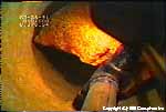
Our Cues RVC-360 high-resolution color video camera is the finest borehole camera available
today. Its fully articulating lens and unprecedented picture clarity allow detailed viewing of both
casing and open hole, including such subtle geologic features as formation contacts, joints, and even cross-bedding. Our
MLS Series 1500 wireline logging unit includes a digital acquisition system which allows virtually
limitless display options.
 The Geonics EM-39 borehole electromagnetic logger is especially
useful in mapping the vertical extent of contaminant plumes. Any of our borehole
methods can be used in conjunction with surface geophysical techniques to provide
the most comprehensive geophysical site evaluation available.
The Geonics EM-39 borehole electromagnetic logger is especially
useful in mapping the vertical extent of contaminant plumes. Any of our borehole
methods can be used in conjunction with surface geophysical techniques to provide
the most comprehensive geophysical site evaluation available.
Applications of Downhole Methods
Borehole video and geophysical logging tools can provide critical answers to a number of questions encountered in ground
water, environmental, and geotechnical work, including:
- Inspection and verification of well construction
- Detailed stratigraphic evaluation
- Vertical contaminant plume definition
- Aquifer identification for setting of well screens and casing
- Fracture zone identification
- Identification of potential contamination zones
- Evaluation of well conditions prior to sealing and abandonment
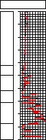
Video Inspections
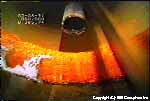
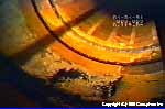
 Video inspections provide a continuous, permanent visual record
of the well casing, screen, or open hole. A video camera built into a waterproof
stainless steel housing is lowered into the well via a triple-armored coaxial
cable. The image is transmitted back via the cable to a VHS recorder and monitor
at the surface. This arrangement provides a permanent videotape recording,
as well as real-time viewing, which facilitates detailed inspections
of features of interest. The RVC-360 is a new generation borehole
video system. The fuzzy, monochromatic picture characteristic of older borehole
cameras has been replaced by a remarkably sharp, full-color image.
The joystick-controlled articulating lens allows either a close
look at the side of the well or a wide-angle axial view, all in a single run.
These remarkable capabilities have proved extremely useful in providing detailed
screen inspections, identifying cracks and holes in casings, delineating
fracture zones and ground water flow, evaluating specific formations
for aquifer development, and locating lost tools and equipment(see
stills from downhole camera).
Video inspections provide a continuous, permanent visual record
of the well casing, screen, or open hole. A video camera built into a waterproof
stainless steel housing is lowered into the well via a triple-armored coaxial
cable. The image is transmitted back via the cable to a VHS recorder and monitor
at the surface. This arrangement provides a permanent videotape recording,
as well as real-time viewing, which facilitates detailed inspections
of features of interest. The RVC-360 is a new generation borehole
video system. The fuzzy, monochromatic picture characteristic of older borehole
cameras has been replaced by a remarkably sharp, full-color image.
The joystick-controlled articulating lens allows either a close
look at the side of the well or a wide-angle axial view, all in a single run.
These remarkable capabilities have proved extremely useful in providing detailed
screen inspections, identifying cracks and holes in casings, delineating
fracture zones and ground water flow, evaluating specific formations
for aquifer development, and locating lost tools and equipment(see
stills from downhole camera).
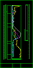
Geophysical Logging
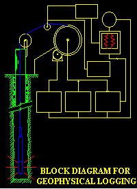 Geophysical logging (sometimes erroneously called "electric logging")
is a generic term encompassing a wide variety of techniques. Simply put, geophysical
logging is the measurement of various physical parameters by the lowering
of a probe or sonde containing sensors into a well or borehole. These parameters
can then be used to evaluate the geology and well construction. The data are transmitted
to the surface via the logging cable, where they are collected, processed, and
plotted in the familiar log formats. Some of the geophysical logging techniques
available include natural gamma ray, electric,
and borehole caliper.
Geophysical logging (sometimes erroneously called "electric logging")
is a generic term encompassing a wide variety of techniques. Simply put, geophysical
logging is the measurement of various physical parameters by the lowering
of a probe or sonde containing sensors into a well or borehole. These parameters
can then be used to evaluate the geology and well construction. The data are transmitted
to the surface via the logging cable, where they are collected, processed, and
plotted in the familiar log formats. Some of the geophysical logging techniques
available include natural gamma ray, electric,
and borehole caliper.
Natural Gamma Ray Logging
All rocks and soils emit gamma radiation in varying amounts.
The primary gamma emitting materials are potassium 40, uranium,
and thorium. These elements tend to congregate in relatively greater
amounts in fine-grained sediments. By measuring the amount of emitted gamma radiation
as a function of depth, we can paint an accurate "picture" of the nature of the
material penetrated by the well.
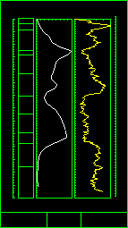
Electric Logging
Electric logging uses the marked differences in electrical properties between fine-grained
sediments (shale, clay, and silt) and coarser-grained material (sandstone, sand, and gravel), to identify stratigraphic units
from logs of electrical resistivity and natural electric potentials. Electric logging encompasses a number of specific techniques, including
single-point resistance, spontaneous potential (SP), resistivity,
and electromagnetic induction (EM). Single-point resistance simply involves measuring the bulk
resistance between a surface electrode and the downhole probe. Spontaneous potential measures natural voltages
produced by electrochemical differences between sands, clays, and the borehole fluid. Resistivity uses a probe with four
(or more) individual electrodes to measure the electrical resistivity of the formation surrounding the probe. EM logging
yields conductivity (reciprocal of resistivity) by measuring the response to an induced electromagnetic field, thus
permitting contamination levels to be determined through a plastic casing. The uses for these methods are many and varied, from
identifying sands and gravels for screen placement, to determining water quality and locating contaminant plumes
.
Caliper Logging
A caliper log is simply a record of the changes in hole diameter with depth. The probe has
three mechanical arms which are opened at the bottom of the well, where they expand to the diameter of the borehole. As the tool is drawn
up the well, the arms expand and contract as the hole diameter changes. The probe detects the extent to which the arms are opened and
sends the measurement to the surface, providing an accurate log of borehole diameter.
Field Procedures
Field procedures for most logging programs can be simple or complex, depending on the methods chosen, location,
access to the well, and the nature of the borehole. The probe is suspended from a pulley into the well, and the depth referenced to a
common datum. It is then lowered to the point of refusal at the well bottom and the uphole equipment is set for depth and scales.
As the sensors receive information it is sent back to the surface unit, where it is processed and plotted in analog format. The raw data are
also collected digitally on a microcomputer for later processing and plotting. Although the
convention for most logs is to acquire the data while tripping out of the hole, a few methods, such as EM, temperature,
and flow meter logging, are performed while lowering the probe into the well.
Summary
Geophysical logging has been used extensively in oil and gas exploration. Essentially every petroleum well drilled has a
wireline logging program as part of its completion. These methods are now widespread in the ground water industry, and becoming increasingly
common in environmental work. The information gathered through a properly conceived and executed geophysical logging program often cannot
be achieved in any other way. Geosphere is among the leaders nationwide in applying professional, state-of-the-art borehole logging and video
services to ground water and environmental wells and borings.
Return to Geosphere front page or methods.

email:
consultants@geosphereinc.com
124 north auburn road auburn, mi 48611 tel: (989) 662-6149
fax: (989) 662-7701
copyright ©1990-2007 geosphere inc